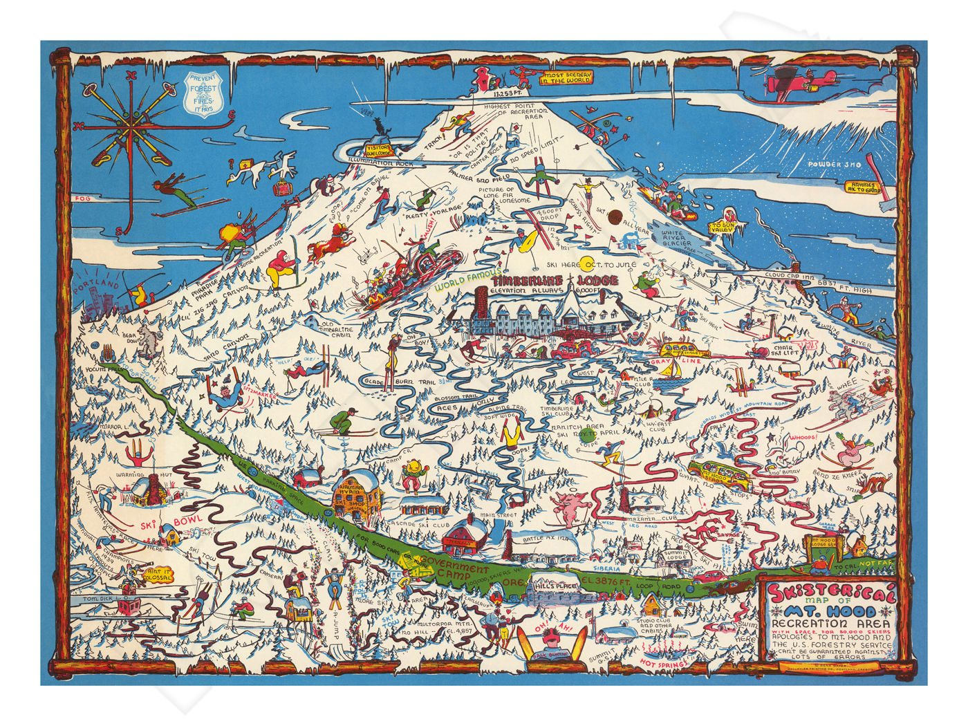

This beautiful poster has been re-mastered from a 1939 pictorial map of Mount Hood and the snow skiing facilities there. This “Skisterical” poster uses comical illustrations to highlight famous landmarks and facilities at Mount Hood.
The vibrant colors and detail of this classic image have been painstakingly brought back to life to preserve a great piece of history.
The high-resolution image is printed on heavy archival photo paper, on a large-format, professional giclée process printer. The poster is shipped in a rigid cardboard tube, and is ready for framing.
The 18”x24” format is an excellent image size that looks great as a stand-alone piece of art, or grouped as a visual statement. These posters require no cutting, trimming, or custom framing, and a wide variety of these frames are readily available at your local craft or hobby retailer, and online. This poster has a 1” white border.
A great vintage print for your home, shop, or business!
MOUNT HOOD & PICTORIAL MAPS
MOUNT HOOD
Mount Hood is a potentially active stratovolcano in the Cascade Volcanic Arc. It was formed by a subduction zone on the Pacific coast and rests in the Pacific Northwest region of the United States. It is located about 50 miles east-southeast of Portland, on the border between Clackamas and Hood River counties. In addition to being Oregon's highest mountain, it is one of the loftiest mountains in the nation based on its prominence, and it offers the only year-round lift-served skiing in North America.
PICTORIAL MAPS
Pictorial maps (also known as illustrated maps, panoramic maps, perspective maps, bird’s-eye view maps, and geopictorial maps) depict a given territory with a more artistic rather than technical style. It is a type of map in contrast to road map, atlas, or topographic map. The cartography can be a sophisticated 3-D perspective landscape or a simple map graphic enlivened with illustrations of buildings, people and animals. They can feature all sorts of varied topics like historical events, legendary figures or local agricultural products and cover anything from an entire continent to a college campus.
Pictorial maps usually show an area as if viewed from above at an oblique angle. They are not generally drawn to scale in order to show street patterns, individual buildings, and major landscape features in perspective. While regular maps focus on the accurate rendition of distances, pictorial maps enhance landmarks and often incorporate a complex interplay of different scales into one image in order to give the viewer a more familiar sense of recognition. With an emphasis on objects and style, these maps cover an artistic spectrum from childlike caricature to spectacular landscape graphic, with the better ones being attractive, informative and highly accurate. Some require thousands of hours to produce.