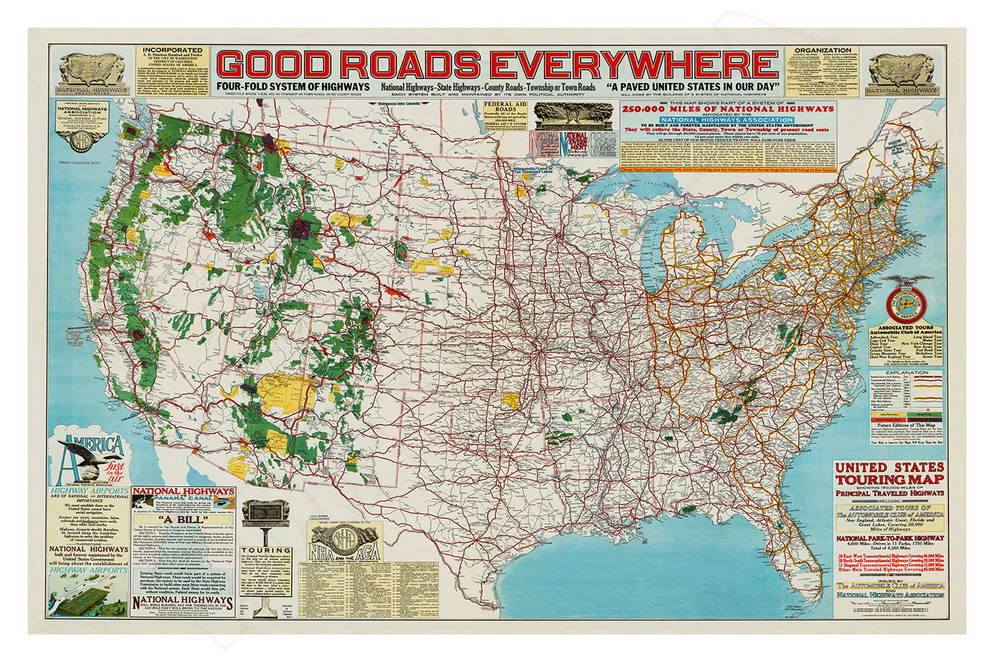
This beautiful reproduction poster has been re-mastered from a vintage 1925 map showing “Good Roads” in the U.S., Transcontinental Routes.
The vibrant colors and detail of this classic image have been painstakingly brought back to life to preserve a great piece of history.
The high-resolution image is printed on heavy archival photo paper, on a large-format, professional giclée process printer. The poster is shipped in a rigid cardboard tube, and is ready for framing.
The 24”x36” format is an excellent image size that looks great as a stand-alone piece of art, or grouped as a visual statement. The 24”x36” size has a 1” white border. These posters require no cutting, trimming, or custom framing, and a wide variety of these frames are readily available at your local craft or hobby retailer, and online.
A great vintage print for your home, shop, or business!
U.S. TRANSCONTINENTAL ROUTES & EARLY AUTOMOBILE ROADS
This historic map issued by the National Highway Association and the Automobile Club of America, shows the symbols and routes of named highways and trails including: Lincoln Highway, National Old Trails Road, Dixie Highway, Pikes Pk. Ocean-Ocean Hwy., Yellowstone Trail, Atlantic Highway, Pacific Highway, Meridian Highway, Midland Trail, Arrowhead Trail, King of Trails, National Park-Park Hwy., Bankhead Highway, Southern National Hwy., Jefferson Highway, Jackson Highway, Old Spanish Trail, Dixie Overland.
EARLY AUTOMOBILE ROADS
In the early days of automobile road building, the routing of the roads was often handled by numerous private committees, and they were heavily influenced by the Automobile Club of America, the Automobile Association of America (AAA), and their local branches such as the Automobile Club of Southern California (ACSA).
During these years, the federal government had minimal involvement in routing and financing, so these issues were generally left up to local governments and committees.
National Old Trails Road was established in 1913, and it became known as the nation’s first “Ocean to Ocean Highway. The route for National Old Trails Road underwent numerous changes, and the states, counties, and towns along the way fought tooth and nail to ensure the great road would pass through and benefit their areas.
Roads didn’t become “automobile roads” until the early 1900s, when automobiles became widely produced and affordable.
Automobile roads were such a new concept in the early 1900s, that rivers, canyons, and gorges were typically only spanned by bridges built for the railroads. Wagons and automobiles had to go around the obstacles, or be ferried across the rivers.
There wasn’t an automobile bridge built across the Colorado River between California and Arizona until 1915, when the Old Trails Bridge near Topock, Arizona, and the Ocean-to-Ocean Bridge near Yuma, Arizona, were built.
Automobiles were dramatically increasing the mobility of the American public, and the unstoppable phenomenon was forcing a revolution in road building across the country.
In July 1916, congress passed the 5-year, $75 million dollar Federal-Aid Road Act, which was the first major federal program established for the purpose of building roads. California received an appropriation of $151,000 for fiscal 1917, and by the end of that year, every state had a highway agency to administer the federal funds.
Under the Road Act, the states could choose their own road projects, but they were required to provide 50% of the funding, and all roads had to be toll-free, and approved by the federal government.
Under the Road Act, the states could choose their own road projects, but they were required to provide 50% of the funding, and all roads had to be toll-free, and approved by the federal government.
By 1921, there were more than 10 million automobiles in the U.S., and their owners were eager to travel on good roads. The 1916 Federal-Aid Road Act was expiring that year, and congress passed a milestone highway bill known as the Federal Highway Act of 1921.
The bill allocated $75 million annually to fund roads, and this act was targeted toward roads of “interstate or primary character.” States had to continue matching funds, and the new road width had to be at least 18 feet wide.
In 1926, the United States Numbered Highway System was adopted, and that’s when sections of National Old Trails Road became Route 66. The numbering system helped to unscramble the national maze of road and trail names that started and stopped randomly, and caused endless frustration for automobile drivers.
top of page
$34.95Price
These are simply the best posters available! You will be thrilled with the image quality, vivid colors, fine paper, and unique subjects.
Our posters are sized for standard off-the-shelf frames, with no custom framing required, providing huge cost savings!
Related Products
bottom of page


