
These are simply the best posters available…you will be thrilled with the image quality, vivid colors, fine paper, and unique subjects! This is a unique remastered image, transformed into a beautiful poster - available exclusively from Posterzilla.
OUR POSTERS ARE SIZED FOR STANDARD OFF-THE-SHELF FRAMES, WITH NO CUSTOM FRAMING REQUIRED, PROVIDING HUGE COST SAVINGS!
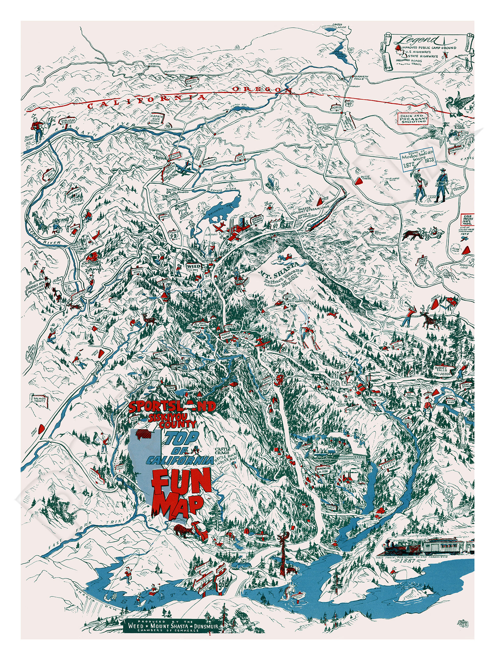
This beautiful reproduction poster has been re-mastered from an original 1950 fun pictorial map for Mount Shasta and Siskiyou County, showing the recreational and geographic features of the area. The map was produced by Mount Shasta, Dunsmuir, and Weed Chambers of Commerce.
The vibrant colors and detail of this classic image have been painstakingly brought back to life to preserve a great piece of history.
This high-resolution image is printed on heavy archival photo paper, on a large-format, professional giclée process printer. The poster is shipped in a rigid cardboard tube, and is ready for framing.
The 24"x32" format is an excellent image size that looks great as a stand-alone piece of art, or grouped as a visual statement. These posters require no cutting, trimming, or custom framing, and a wide variety of these frames are readily available at your local craft or hobby retailer, and online.
A great vintage print for your home, shop, or business!
HISTORY OF THE MOUNT SHASTA AREA
Mount Shasta is a potentially active stratovolcano at the southern end of the Cascade Range in Siskiyou County, California. At an elevation of 14,179 ft, it is the second-highest peak in the Cascades and the fifth-highest in the state. It is surrounded by the towns of Mount Shasta, Dunsmuir, and Weed.
The Smithsonian Institution's Global Volcanism Program says the last known eruption of Mount Shasta was around 1250 AD, proved by uncorrected radiocarbon dating.
The first written record and description of Mount Shasta was made on May 20, 1817, by Spaniard Narciso Durán, a member of the Luis Antonio Argüello expedition into the upper areas of the Sacramento River Valley.
Beginning in the 1820s, Mount Shasta was a prominent landmark along what became known as the Siskiyou Trail, which runs at Mount Shasta's base. The Siskiyou Trail was on the track of an ancient trade and travel route of Native American footpaths between California's Central Valley and the Pacific Northwest.
The first recorded ascent of Mount Shasta occurred in 1854 (by Elias Pearce), after several earlier failed attempts.
The 1887 completion of the Central Pacific Railroad, built along the line of the Siskiyou Trail between California and Oregon, brought a substantial increase in tourism, lumbering, and population into the area around Mount Shasta. Early resorts and hotels, such as Shasta Springs and Upper Soda Springs, grew up along the Siskiyou Trail around Mount Shasta, catering to these early adventuresome tourists and mountaineers.
In the early 20th century, the Pacific Highway followed the track of the Siskiyou Trail to the base of Mount Shasta, leading to still more access to the mountain. Today's version of the Siskiyou Trail, Interstate 5, brings thousands of people each year to Mount Shasta.
From February 13–19, 1959, the Mount Shasta Ski Bowl obtained the record for the most snowfall during one storm in the U.S., with a total of 15.75 feet.
Mount Shasta was declared a National Natural Landmark in December 1976.